Yunotsu Port
35 05.760N 132 20.330E
| A~B間、係留状況【Berth】 | 係留場所【Berth】 |
|
|
| 例外係留(漁協前) | 例外係留(C防波堤海側) |
| |
|
Google Map Hamada Port→Yunotsu Port 2014.6.30
Google Map Yunotsu Port→Sagiura 2014.7.2
Google Map Sagiura→Yunotsu Port 20014.8.2
Google Map Yunotsu Port→ Hamada Port 20014.8.2
Google Map Hamada Port→Yunotsu Port 2009
Google Map Yunotsu Port→Sagiura 2009
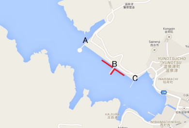
Note for English Version: Inside Yunotsu Port, there are three breakwaters
running from the north side land.
To discriminate them, we call them (A), (B) and (C) in order from the west
(seaside) as you see on the map.
(A) breakwater is located outermost in the west.
There is a white lighthouse with a green light at the top of (A) breakwater.
The area between (A) and (B) breakwaters is a quay for work ships.
(B) breakwater is located between (A) and (C).
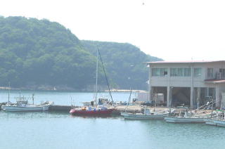
The area between (B) and (C) is a fishing port, which has Gyokyo office,
i.e.
Fisheries Cooperative Association.
(C) breakwater is located innermost in the east of Gyokyo.
A boats pool is in the east of (C) breakwater.
August 2, 2014
I bothered about a southeast wind this time.
As Yunotsu Port has mountains in the southeast, I had thought the southeast
wind should be weakened.
But, the wind was rather strengthened. It was like a wind path.
This time, first, I moored at the quay for work ships between (A) and (B)
breakwaters.
Second, I moved to the fishing port quay closer to (B) between (B) and
(C), then moved to the seaside (west side) of (C).
I tried three berths.
While Gyokyo accepts basically a berth closer to (B) between (B) and (C)
and another berth at the east side of (B) only, they guided me to the west
side of (C) because there was a festival at that time.
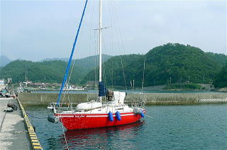
As (C) is a very low breakwater, be careful with your fenders positions.
The quay between (A) and (B) for work ships are always open for mooring, because that area is beyond the jurisdiction of Gyokyo.
June 5, 2014
No status change from 2009 below. You should not think about mooring at
the boats pool.
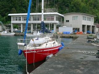
As there is a loading place in front of Gyokyo office, you moor at the
quay closer to (B) between (B) and (C).
If it is full of fishing boats, moor at the quay between (A) and (B).
I moored hear this time. As the distance between bitts is about 30meters,
you should be prepared with long ropes.
June 14, 2009
Approaching Yunotsu Port:
You head straight to the white lighthouse with green light.
The lighthouse is not so visible from the distance.
Around the entrance of Yunotsu Port, there is the first breakwater running
from the northeast.
Then, the second breakwater is running from the southwest.
After passing by the second breakwater, you will pass by the white lighthouse
at (A) breakwater on your left.
Ask Gyokyo office directly for your berth. Otherwise, advices to your berth
vary person to person in the fishing port.
They are kind and not rejecting sail boats though.
A 24-hour-open clean western style toilet is at the tourist information
office in front of the port.
Water is available at the toilet. The toilet at Gyokyo can be OK for a
small bucket of water.
No coin laundry.
There is a small supermarket 3 minutes away.
Another bigger supermarket is 7 minutes away on the way to the station.
No fuel station around.
There is one at a national highway beyond the station.
I called Ogawa Shop at 0855-65-3122 to deliver 80 liters of fuel.
As Yunotsu is an Onsen sightseeing place, there a few restaurants in 10
minutes away.
“Moto-yu” is a wonderful homespun Onsen bathhouse and opens at 5:30 early
in the morning.
“Yakushi-yu” is another good one. Both fees are JPY300.
http://www.yunotsu.com/
Additional Information for English Version
Yunotsu literally means Onsen hot spring port. “Yu” means hot water. Yunotsu
has Japanese web site:
http://www2.crosstalk.or.jp/yunotsu/
Yunotsu was the port of Iwami Silver Mine, which produced one third of
the global silver in 17th century.
http://www2.crosstalk.or.jp/yunotsu/iwami.html