

伊豆七島
式根島 吹の江
Fukinoe Cove at Shikine-jima Island, Izu Seven Islands
34 20.150N 13912.495E(吹の江入ってすぐ)
艇を留める位置の詳細は下記Google Mapで航空写真を選択し、拡大
googlemap 神津島三浦港→式根島吹の江
googlemap 式根島吹の江→式根島野伏港
航路情報
神津島 多幸湾 三浦漁港→吹の江
式根島吹の江→式根島野伏港
BLOG
自然に対し常に謙虚に。西の風強くは危険 2012.5.18
関東で最も美しい泊地、吹の江にやってきまし 2012.5.17
三宅島阿古港から式根島、吹の江へ 2005.6.30
吹の江でガンクホリック、式根島探索 2005.7.1
式根島 吹の江
泊地情報 2012.5.17:
吹の江はヨットで行ける関東では最も美しい入江と思う。
沖縄の美しさとはまた、別な独特の雰囲気を持った素晴らしい泊地です。
是非、体験してみてください。
式根島 吹の江へのアプローチ:
waypointに34 20.470N 139 12.5300Eと34 20.150N 139 12.4950Eを設定して欲しい。
最初のwaypointは吹の江の奥までを見渡せる位置だ。
先ずここまで船を進め、34 20.150N 139 12.4950Eへ船を進める。
私は何度も吹の江へ行っている。
しかし、いつも目視で、入口はどこだっけと迷う。
夏休みなどは入っているヨットが見えるので解るが、
船が居ない時は非常に入口が解り難い。
今回、正確に吹の江の奥まで見渡せる緯度経度、
吹の江に入ったところの緯度経度を出した。
吹の江に入る参考にして欲しい。
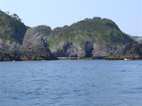
入口左の洗岩に注意!
頭は見えるので、気が付かないということは無いと思う。
しかし、満潮の時に見え難い。
入るに当たっては、この洗岩と右の岩との狭い間の中間を進む。
アンカーを2つ用意!
吹の江は全く自然の入江なので船を着けたりは出来ない。
ビットは何か所かあるが、舫うにはテンダーで船から陸まで行く必要がある。
その為には一旦、船を固定しなければならない。
そこで、アンカーを2つ打ち、船を一旦固定する。
テンダーが必要!
岩に埋め込まれたビットに舫いを取る為に、テンダーで行くしかない。
アンカーのみで無く、船尾か船首1箇所はビットに必ず舫うこと!
吹の江の海底は岩と砂で錨利きは良く無い。
狭いので、走錨したら即、船体の破壊となる。
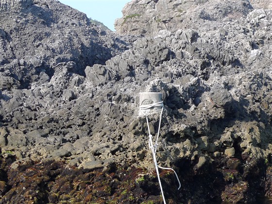
ビットの摩擦に注意!
左下の様に行って来いにロープを取った場合、
摩擦でロープが動きません。
シングルなので、前回は舫いロープを置いてきました。
今回(2012.5.17)は三打ちロープだから大丈夫だろうと思いましたが、
やはり全く動きません。
右下の様に別のロープをビットに巻き、
アイを作って、そのアイにロープを通す様にしてください。
今回もこのアイ2つ付きのロープは置いてきました。
吹の江での位置:
奥の砂地に近づくと浅くなる。
測深機の表示を見ながら、かつ干潮時もOKかを計算しながら、
何処に船を固定するかを考える。
右手の大きなビットがあるところは比較的、水深が深い。
全体が狭いので、5艇程度が限度と言える。
#携帯がつながり難い
ここは、人家からは遠く離れている為、携帯の電波が弱い。
つながるのが普通の状態だが、何故かつながらなく時があるので注意。
#西の風強くは危険
吹の江は風が強くても安全と言われている。。
しかし、西の風強くの場合、狭い入口は波で吹の江から出る事が出来ない。
非常に危険になる。天気予報を事前に必ずチェックすること。
吹の江からテンダーで上陸後は岩に作られた道を登り上に出る。
草木に囲まれた道と見えない道を登ることになる。
出たところはヘリコプターの発着所となっている。
水:無い
トイレ:砂浜から岩の間を登り、ヘリ着陸広場にでる。道に出て左に進むと泊港の上に出る。
シャワー設備もある立派なトイレ。洋式あり。
風呂:式根島は温泉の島。温泉銭湯にあたるのは憩いの家。200円。
是非体験したいのは谷底の「秘湯」地鉈温泉 。浜の露天風呂、足付温泉も一度は行ってみたい。
燃料:海福燃料店 04992-7-0032 井上燃料店04992-7-0100
コインランドリー:無い。
食材調達店:小さな食材店が何軒かある
食事:色んなところにあるが、白石川海岸近くに特に多い。
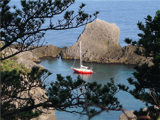
| 係留状況【Berth】 | 入口風景、洗岩 |
 |
 |
| ビット係留状況 | 上の道に出る階段 |
 |
 |
| 係留状況【Berth】 | ビット |
 |
 |
Fukinoe Cove at Shikine-jima Island, Izu Seven Islands
google map Miura Fishing Port at Kozu-shima Island→Fukinoe Cove at Shikine-jima Island
google map Fukinoe Cove at Shikine-jima Island→Nobuse Port at Shikine-jima Island
May 17, 2012
Fukinoe is a most beautiful cove and anchorage for sail boats in Kanto
area.
The beauty of the anchorage has distinctive atmosphere, which is different
from the beauty in Okinawa.
I strongly recommend your anchoring experience in the cove.
A small tender boat is required, because Fukinoe is a natural cove with
no artificial quay.
Just a few bitts are built into rocks.
To put your dock lines on those bitts, you need a tender to go there.
Approaching Fukinoe Cove:
Make two waypoints: 34 20.470N 139 12.5300E and 34 20.150N 139 12.4950E. At the first waypoint, you will have a view of the whole
cove to the back.
Then, you may move to the second waypoint.
I have visited Fukinoe many times. But, only with visual navigation, I
was always lost and not able to find the entrance of the cove.
In summer time for example, as masts of yachts were seen from outside of
the cove, I was able to find the entrance.
Without those masts, it is hard to find the entrance.
So, please utilize the two waypoints above to move into the cove.
At the left side of the entrance, there is a rock being washed with waves.
While the top of the rock can be seen above the sea surface, it is hard
to find at full flood.
Move through a narrow water way between the rock on your left and another
rock on your right.
Drop two anchors to fix your boat position first.
Then bring your dock lines with the tender to put them on the bitts on
rocks.
As the seabed of the cove is rock and sand, the anchor doesn’t hold well.
Once the anchor drags, your boat hits rocks around the small cove.
So, even at anchor, you need to moor at the bitt with a bow line and/or
a stern line.
Even if you try to pull out the one end of the line around the bitt when
you leave the cove, you won’t be able to pull out the line because of the
friction between the line and the bitt.
As a solo sailor, I left a line there last time.
This time, I had thought the friction would be OK with a new line though,
it was no good again.
The solution: Put a loop line which can be left on the bitt.
Then, moor at the loop line with the dock line.
This time, I used and left a line with two eyes as you see on the pictures.
The area of the cove is small. Its inside space would be full with five
boats.
It is getting shallow at the sand seabed in the back.
Checking the depth meter and calculating the depth at low tide, decide
the to-be-fixed boat position in the small cove.
Around the bitt on your right, it is relatively deep.
As the cove is far from the village, your mobile phone will not be connected
well.
While it is safe inside the cove, as waves roll in at the narrow entrance,
you can’t get out the cove when westerly wind gets strong.
Check your weather forecast.
After coming ashore with the tender, you climb up a narrow pathway, which
is overhung with vegetation between rocks.
It is dangerous at night.
The top of the pathway is an open space for a helicopter pad.
No water nor no coin laundry nearby.
A western style toilet with shower is above Tomari Port.
Go out the helicopter pad area to a road, turn left and you will be there.
Shikine-jima is an Onsen (spa) island.
Ikoi-no-ie is a public bathhouse for JPY200.
Jinata Onsen at the bottom of a rock beach is strongly recommended.
Ashitsuki open-air-at-beach Onsen is another recommendation.
Fuel (Nenryo in Japanese): Kaifuku Nenryo 04992-7-0032, Inoue Nenryo 04992-7-0100
There are small food shops. There are many restaurants, especially around
Shiraishigawa Beach.
Additional Information for English Version
Tokai Kisen, a ferry company for Izu Seven Islands, has English introduction
of each island:
http://www.tokaikisen.co.jp/english/island/shikinejima/
Kuroshio, a strong ocean stream, is running through Izu Seven Islands.
As Kuroshio changes its course frequently, visit Japan Coast Guard’s weekly-updated
report:
http://www1.kaiho.mlit.go.jp/KAN3/kaisyo/kaikyo/sokuho/sokuho.html