

泊地情報
温泉津港
Yunotsu Port
35 05.760N 132 20.330E
艇を留める位置の詳細は下記Google Mapで航空写真を選択し、拡大
Google Map 浜田港→温泉津港2014.6.30
Google Map 温泉津→鷺浦2014.7.2
Google Map 鷺浦→温泉津20014.8.2
Google Map 温泉津→浜田港2014.8.4
Google Map 浜田港→温泉津港2009
Google Map 温泉津→鷺浦 2009
航路情報
鷺浦→温泉津
浜田港→温泉津港
温泉津→浜田港
BLOG
ヨットで温泉津港を訪れる2009.6.14
温泉津再訪2014.6.30
温泉津で南東の風に悩ませられる2014.8.2
温泉津港 泊地情報:
2014.8.2
今回は南東の風に悩ませられた。
温泉津では南東の場合、山をしょっているので、弱くなると想定していたが、
むしろ非常に強まる。
風の通り道になるようだ。
今回初めて、漁港に留めたが、
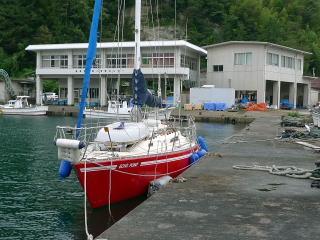
漁港岸壁(C防波堤))は非常に低い。
フェンダーの位置に注意。
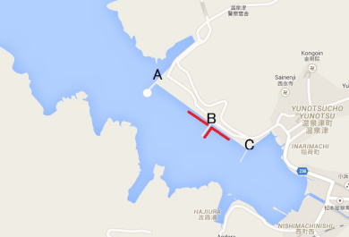
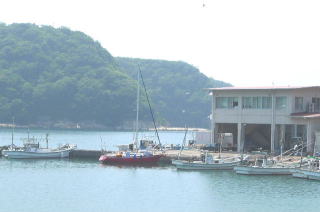
今回、最初に工事船岸壁(A防波堤とB防波堤の間)、次に漁港岸壁(B、C防波堤間のBより)に移動。
さらに漁港前の桟橋(C防波堤)海側に移動。
3か所に留めたことになる。
漁協が認めているのは漁港東岸壁(B、C防波堤間のBより)とB防波堤の南側だ。
外の工事船が留まる工事船岸壁(A防波堤とB防波堤の間)はいつも空いており、漁協管轄外で自由に留められる。
今回、漁港前の桟橋(C防波堤)海側に留められたのはお祭で、漁師さんが便宜を図ってくれた。
2014.6.30
下記に同じ。特に変化無し
船溜まり(C防波堤の南側)への係留は無理と考えた方が良い。
漁協が認めているのは漁港東岸壁(B、C防波堤間のBより)が漁船で一杯の場合は、
工事船岸壁(A防波堤とB防波堤の間)に留める。
今年は内側防波堤の中は何艇か漁船が横着けしていたので、私は工事船岸壁に留めた。
ビット間の距離が30m位あるのでロープの用意が必要。
2009.6.14
温泉津港へのアプローチ:
温泉津沖から真っ直ぐ、港湾案内の緑色灯台を目指す。実際は白灯台。わりと見難い。
灯台に近づく手前先ず港入口に東より伸びる防波堤がある。次に西から伸びる防波堤がある。
それを過ぎ白灯台を左に見て港内部に入ると東より2本の堤防が出ている。
白燈台と1本目の堤防の間の岸壁は製造した砂などの積荷降ろしなどをおこなう。
漁港では無い。
白燈台を過ぎ一本目の堤防と漁協の建物のそば、2本目の堤防の間が漁港。
日曜だったが、出ていた事務職らしい漁協員に聞いたところ、初めの堤防の南側と東岸壁なら良いとの回答であった。
日本目の堤防の奥、一番静穏な地元漁船の場所はダメとのこと。
2本目の防波堤の先、海側でも良いとのことであったが、岸壁の漁師らしき人は網を下ろすのであそこはダメのはずだとのことであった。
私の場合、一旦一番奥の地元漁船に船溜まりの空いたところに槍付けし、漁協に聞いて1本目堤防内側に槍付けした。
その後すぐ年配の漁師さんとさっきの事務の人が来て申し訳無いがここに網を持ってくることになったので移動して欲しいと言われる。
年配の漁師さんが静かだから一番奥の空いている所に留めて良いと言ってくれる。
船を移動すると先ほどの漁師さんが岸壁でこのに着けろと待っていてくれ、舫いを取ってくれた。一番奥の静かな場所に係留できた。
漁協に先ず着ける場所を相談するのが良い。人によって回答はまちまちのようだ。
みな穏やかで排斥するような様子は全く無い。
トイレ:2分。港に面した観光案内所に24時間オープンのきれいなトイレがある。洋式有り
コインランドリー:無い
食品類買物:3分に小型スーパー。駅に向かい7分ぐらいでもう少し大きなスーパー。
燃料:近くには無い。駅の先、国道沿い。私の場合、80Lだったが、小川商店0855-65-3122に電話すると持って来てくれた。
食事:温泉観光地なので10分以内に何軒かある。
風呂:元湯、素朴な素晴らしい温泉。もう一軒、薬師湯。両者300円。元湯は朝5半からやっている。
水:観光案内所横トイレ。漁協。ポリタン程度なら漁協のトイレ横の蛇口を使って良いと言われる。
泊地情報、航路情報一覧に戻る
| A〜B間、係留状況【Berth】 | 係留場所【Berth】 |
 |
 |
| 例外係留(漁協前) | 例外係留(C防波堤海側) |
 |
 |
Google Map Hamada Port→Yunotsu Port 2014.6.30
Google Map Yunotsu Port→Sagiura 2014.7.2
Google Map Sagiura→Yunotsu Port 20014.8.2
Google Map Yunotsu Port→ Hamada Port 20014.8.2
Google Map Hamada Port→Yunotsu Port 2009
Google Map Yunotsu Port→Sagiura 2009
Note for English Version: Inside Yunotsu Port, there are three breakwaters
running from the north side land.
To discriminate them, we call them (A), (B) and (C) in order from the west
(seaside) as you see on the map.
(A) breakwater is located outermost in the west.
There is a white lighthouse with a green light at the top of (A) breakwater.
The area between (A) and (B) breakwaters is a quay for work ships.
(B) breakwater is located between (A) and (C).
The area between (B) and (C) is a fishing port, which has Gyokyo office,
i.e.
Fisheries Cooperative Association.
(C) breakwater is located innermost in the east of Gyokyo.
A boats pool is in the east of (C) breakwater.
August 2, 2014
I bothered about a southeast wind this time.
As Yunotsu Port has mountains in the southeast, I had thought the southeast
wind should be weakened.
But, the wind was rather strengthened. It was like a wind path.
This time, first, I moored at the quay for work ships between (A) and (B)
breakwaters.
Second, I moved to the fishing port quay closer to (B) between (B) and
(C), then moved to the seaside (west side) of (C).
I tried three berths.
While Gyokyo accepts basically a berth closer to (B) between (B) and (C)
and another berth at the east side of (B) only, they guided me to the west
side of (C) because there was a festival at that time.
As (C) is a very low breakwater, be careful with your fenders positions.
The quay between (A) and (B) for work ships are always open for mooring, because that area is beyond the jurisdiction of Gyokyo.
June 5, 2014
No status change from 2009 below. You should not think about mooring at
the boats pool.
As there is a loading place in front of Gyokyo office, you moor at the
quay closer to (B) between (B) and (C).
If it is full of fishing boats, moor at the quay between (A) and (B).
I moored hear this time. As the distance between bitts is about 30meters,
you should be prepared with long ropes.
June 14, 2009
Approaching Yunotsu Port:
You head straight to the white lighthouse with green light.
The lighthouse is not so visible from the distance.
Around the entrance of Yunotsu Port, there is the first breakwater running
from the northeast.
Then, the second breakwater is running from the southwest.
After passing by the second breakwater, you will pass by the white lighthouse
at (A) breakwater on your left.
Ask Gyokyo office directly for your berth. Otherwise, advices to your berth
vary person to person in the fishing port.
They are kind and not rejecting sail boats though.
A 24-hour-open clean western style toilet is at the tourist information
office in front of the port.
Water is available at the toilet. The toilet at Gyokyo can be OK for a
small bucket of water.
No coin laundry.
There is a small supermarket 3 minutes away.
Another bigger supermarket is 7 minutes away on the way to the station.
No fuel station around.
There is one at a national highway beyond the station.
I called Ogawa Shop at 0855-65-3122 to deliver 80 liters of fuel.
As Yunotsu is an Onsen sightseeing place, there a few restaurants in 10
minutes away.
“Moto-yu” is a wonderful homespun Onsen bathhouse and opens at 5:30 early
in the morning.
“Yakushi-yu” is another good one. Both fees are JPY300.
http://www.yunotsu.com/
Additional Information for English Version
Yunotsu literally means Onsen hot spring port. “Yu” means hot water. Yunotsu
has Japanese web site:
http://www2.crosstalk.or.jp/yunotsu/
Yunotsu was the port of Iwami Silver Mine, which produced one third of
the global silver in 17th century.
http://www2.crosstalk.or.jp/yunotsu/iwami.html