

泊地情報
瀬戸内海
姫島港
Himeshima Port at Hime-shima Island
33 43.050N 131 38.850E
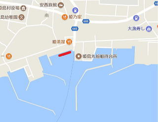
艇を留める位置の詳細は下記Google Mapで航空写真を選択し、拡大
Google Map 安下庄→姫島
google map 姫島→祝島
google map 田野浦→姫島
Google Map 姫島→田野浦
Google Earth 姫島→田野浦
航路情報
安下庄→姫島014.6.14
姫島→田野浦 2017.8.16 2014.6.1
田野浦→姫島 2018.8.31 014.9.17
姫島→祝島014.9.19
BLOG
必ず拍子水には行きます 2018.8.31
姫島にはどうしても寄ります 2017.8.16
またまた大好きな姫島にやって来ました。2017.7.17
ヨットで初めて姫島を訪ねる09.5.29
姫島再訪2014.6.14
愛する姫島再再訪2014.9.17
姫島港
泊地情報:
2018.8.31
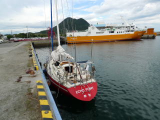
初めて、最初から奥の岸壁に横付けしました。
以前はこの岸壁に留められず、突堤の先端に槍着けしていました。
今は、奥の岸壁でも漁師さんから怒られない様になりました。
ただし、岸壁に槍着けは漁船の荷下ろしに邪魔になるので横付け。
ゴムのハシゴが岸壁に設置されている所がベスト。
2017.8.16
特に変化無し。
拍子水等に行く無料バスの時刻表はフェリーターミナルには無く、
外の向かいに、観光案内所と書いてあるところで貰える。
スタンドは以下の他にバス通りにも有りました。
2017.7.17
正面の岸壁も留められる様です。
今回、30Fの淡輪のヨットが留めていたので、聞いたところ、
水深は大丈夫。前に40F程度の大型ヨットを留めているのを見たとのことです。
ただし、コンクリの階段のところは地元船がつくのでそれよりフェリー乗り場寄り。
ゴムの階段があるあたりまで問題ないとのこと。
フェリーの引き波は気になるがそれほどでは無いとのこと。
ここはいつもガランと空いているので、いつもの岸壁がいっぱいの時は良い泊地だ。
スタンド発見。信号から観音崎方面に10m位にあり。
その隣りにヤンマーの鉄鋼所もあり。
その他は特に、2014と変化無し。
拍子温泉行きのバスがフェリー乗り場前から乗れる様になり便利。
A-COOPでの獲れたばかりの魚は扱わなくなりました。残念。新鮮な野菜は今も買えます。
新鮮、うまい、美しい。
2014.9.18
食材仕入れは民間スーパーとA-COOPそれぞれの良さを取り込むのが良い。
A-COOPには地元産農産物と魚あり。
2014.6.14
5年前には港の周囲に無数にあったスチロール旗は殆どなくなっていた。
季節は前と殆ど同じ。
2014.9.17
西からの姫島アプローチ
姫島に近づくと赤い燈台が2つ見える。
右は手前にある一文字の左端灯台
左が奥の入港用赤燈台。
左の赤燈台を右に見て入る。
港内に入ってからは以下を参照。
なお、OLIVE川村さんの情報では西にある風避けフェンスの中が一番静穏とのこと、
強風時にはフェンス内、東岸壁に着けるのが良いと思われる
2009.5.29
東からの姫島へのアプローチ:
私の場合東からアプローチした。網では無いが5マイルぐらい前からスチロールに旗を立てたのが出現する。
南端を過ぎ姫島港に針路を取ると港の入口までこのスチロールに旗が無数にある。
その間を港に向かう。赤い灯台が2つ見える。
左の赤灯台が一文字の左(西)端、港湾案内に緯度経度が出ている灯台で右が港防波堤の入口右(東)側の灯台だ。一文字左の赤灯台を右に次に防波堤赤灯台を右にみて港内に入る。
広い構内の右(東)にオレンジ色のフェリー。
左から伸びたもう一本の防波堤を左に見て進むと左(西)手に真正面(北)から突き出た堤防が見える。
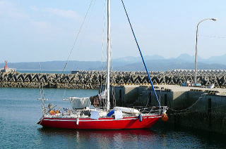
船は港内に1隻も見えない。左堤防の真ん中当たり、階段が付いている位置に係留することに決めて、かなり長くロープを取ってアンカーを打ち槍付けとする。
空いているので横付けも勿論できる。ステンの輪もビットもある。
出来るだけ階段のある所を選んだ方が良い。
瀬戸内海は何しろ干満差が大きい。
注意:付けた防波堤の北の角は石で浅い。
北側は漁船が荷揚げする。
トイレ:フェリー乗り場にはウォシュレットがある。朝5時ごろから開いている。
フェリー乗り場の外には24時間オープンあり。
コインランドリー:なし
食品類買物:2件ある。フェリー乗り場から北へ行き信号右100mで民間
信号を左で農協の店。民間の方が品物は豊富。魚は農協の方が良かった
燃料:未確認
食事:観光地なので何軒かある
風呂:拍子水というすばらしい温泉がある。是非訪問を。町の無料バスを利用。
フェリー乗り場に時間表が張り出してある。
乗る場所は姫島町役場の隣、離島センター前から。港から5分。
水:直ぐそばの漁協。親切だった。またはフェリー乗り場前の公園水飲み場蛇口
泊地情報、航路情報一覧に戻る
| 奥の岸壁に横付け | 係留場所 |
 |
 |
| 泊地【Berth】 | 係留場所【Berth】 |
 |
 |
Himeshima Port at Hime-shima Island
Google Map Agenosho Port→Himeshima Port at Hime-Shima Island
Google Map Himeshima Port at Hime-Shima Islan→Tanoura Port
September 18, 2014
For provisioning, I recommend you to take advantages of both the commercial
supermarket and A-COOP of Nokyo, Agricultural Cooperatives.
A-COOP has locally-sourced fishes and agricultural products.
September 17, 2014
Approaching Himeshima Port from the west:
Approaching Himeshima Port, you will see two red lighthouses.
The right one is at the west end of one-line breakwater in front.
The left one is at the port entrance in the back.
Passing by the left red lighthouse to your right, move into the port.
Following steps are same with below.
A friend of mine says that another place inside windbreak fences located
in the west is the calmest berth.
When the wind is strong, mooring at the east quay the inside windbreak
fences will be good.
June 14, 2014
There is almost no flag which sticks to a foamed-polystyrene buoy, hundreds
of which were floating around the port five years ago.
The season is same with five years ago.
May 29, 2009
Approaching Himeshima Port from the east:
When I approached from the east, there were hundreds of flags which stick
to foamed-polystyrene buoys floating from five miles off the port to the
entrance of the port.
They have hook rigs in the water and stand independently, not connected
each other like fishing net.
I sailed through between them.
Two red lighthouses are seen.
The left one is at the left (=west) end of one-line breakwater.
The right one is at the right (=east) side of the port entrance.
Passing by the red lighthouse at the one-line breakwater to your right,
then passing by the next red light house of the port entrance to your right,
move into the port.
There was an orange ferry boat in the east side within wide port area.
After passing by another breakwater running from the west to your left,
you will see a pier jutting from the north on your left (= west).
I saw no boat inside the port and decided to moor at the center of the
pier, where the quay wall has steps.
I let go anchor with a very long rope and moored my boat bow-to.
As it is open, you may moor alongside.
Stainless rings and bitts can be used for your mooring.
Moor closer to any steps on the quay wall, because the differences in tidal
levels are large in Seto Inland Sea.
Note: It is shallow with rocks at the north corner of the pier.
At the north side, fishing boats are landing fishes.
Toilet with a douche-equipped western style is at the ferry station, which
opens 5am.
Another toilet outside the ferry station opens 24 hours.
No coin laundry.
There are two shops for provisioning.
Walking from the ferry station to the north, there is a traffic signal.
Turn right, walk 100 meters, then there is a commercial shop.
Turn left, there is a shop of Nokyo, Agricultural Cooperatives.
The commercial shop had more goods. The Nokyo shop had better fishes.
Fuel was not confirmed.
There are some restaurants, because here is a sightseeing spot.
Hyoshimizu is a very good Onsen (= spa, hot spring).
I strongly recommend your visit on free shuttle bus of the town.
Bus time table is tacked up at the ferry station.
Bus stop is at Island Center next to Hime-shima Town Hall, 5 minutes walk
away.
Walter was available at nearby Gyokyo: Fisheries Cooperative Association.
They were very kind. Another water tap is at a public water fountain in
a park next to the ferry station.
Additional Information for English Version
Hime-shima Island is in Oita Prefecture, Kyushu, which has English Official
Sightseeing Information Site.
To find spots in Hime-shima, visit:
http://visit-oita.jp/spots/index_english
On the map of the page above, click “Himeshima Village” and click “Search”.
Two spots will be shown. On Japanese pages, more sightseeing spots are
shown such as pictures of Hyoshimizu Onsen:
http://visit-oita.jp/spot/spot0458.html