
伊豆七島
三宅島阿古港
Ako Fishing Port at Miyake-jima Island
34 04.070N 139 28.650E(阿古漁港燈台)
艇を留める位置の詳細は下記Google Mapで航空写真を選択し、拡大
googlemap 利島港→三宅島阿古港012
googlemap 下田→三宅島阿古港012
googlemap 阿古港→御蔵島012
googlemap 阿古港→神津島多幸湾三浦漁港012
googlemap 三宅島阿古港→八丈島神湊港012
航路情報
利島港→三宅島阿古漁港
下田→三宅島阿古漁港012
阿古港→御蔵島012
阿古港→神津島多幸湾三浦漁港012
三宅島阿古港→八丈島神湊港012
BLOG
6、7年ぶりに三宅島阿古漁港にやってきました012
今年2度目の三宅島阿古漁港012
噴火の跡が著しい三宅島を初めて訪れる。.05
三宅島 阿古漁港 泊地情報 2012.5.8:
阿古漁港はクルージングするヨットマンにとって素晴らしい泊地です。
先ず、必ず留められる広い岸壁がある。
かなりの悪い海況でも阿古港の中は静かだ。
何故か漁船の引き波が殆ど無く、ゆっくり眠れる。
次に肉、野菜、魚その他を入手出来る中スーパーがある。
水を24時間、入手出来る。
トイレはウォシュレットが使える。
風呂もコインランドリーも近場にある。
スタンドも近い。
滞在出来ます。
航路
私の場合、利島から向かった際、
1.5〜2ノット弱の逆潮があった。
三宅島に近くなると2〜2.5ノットと逆潮が強まった
三宅島 阿古漁港へのアプローチ:
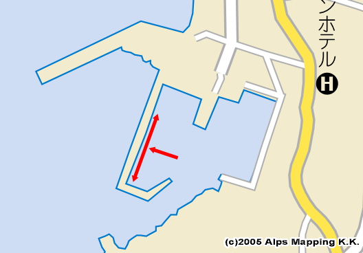
入港に際しては、左に長い堤防の先にある白燈台を見ながら、
右に小さな黄色標識(燈台)をみて進む。
黄色小標識の裏に回る感じで右折する。
奥、左にに小さい白燈台。
小白燈台の根元、狭い航路をすぐ左折する。
広く視野が開ける。
右手に地元船の船だまり。
左に広く空いた岸壁が見える。
この左手の岸壁が係留場所となる。
阿古漁港の係留地:
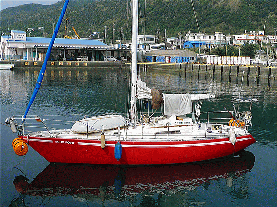
左(西)に広い、係留場所がある。
港に入って、右(東)側が地元船のふなだまり。
奥(北)は荷降ろし、氷積み場所となっている。
西側は1〜2艇、漁船が留まっていても、
広く空いており、ヨットを何艇も着けるスペースが残っている。
#滞在していた時に若い女性が来て、書類に書いてくれと言われる。
港湾と飛行場を管理しているところとのこと。
非常に丁寧な対応。
外来艇の記録と滞在期間等を確認するためらしい。
つまり、この岸壁は漁協管理では無く、港湾、空港管理の部署管轄のようだ。
料金徴収は無し。
水:漁協(未確認)。私は歩いて7分程度にあるキャンプ場「錆ヶ浜園地」まで行った。
トイレ:歩いて7分程度にあるキャンプ場「錆ヶ浜園地」。ウォシュレットです。
東海汽船待ち合わせ場
風呂:ホテル海楽500円。7〜8分ふるさとの湯500円
燃料:6分ぐらい。連絡すれば持って来てくれると思われる
コインランドリー:ホテル海楽200円と安い
店:中型スーパー土屋食品。肉、野菜は種類が無い。物価は東京より高い。
食事:ホテル海楽。他何軒かある
| 泊地【Berth】 | 係留場所【Berth】 |
 |
 |
Ako Fishing Port at Miyake-jima Island
Google Map Ako Port at Miyake-jima Island→Kaminato Port at Hachijyo-jima Island
Google Map Shimoda Port→Ako Fishing Port at Miyake-jima Island
Google Map Toshima Island→Ako Fishing Port at Miyake-jima Island
May 8, 2012
Ako Fishing Port is a good port for yachties.
The port has a quay with wide open space where you may moor anytime.
It is calm inside the port, even when stormy sea outside.
As fishing boats washes are little for some reason, you may sleep well
inside your boat.
There is a supermarket at which you may buy meat, vegetables, fish and
so on. Water is available for 24 hours.
A bidet-equipped TOTO Washlet toilet. Bathhouse, coin laundry and gas stand
are nearby.
A good port for your long stay.
Approaching Ago Fishing Port:
When I approached Miyake-jima Island from north, there was 1.5 to little
under 2.0kt head tide.
Neared the island, the head tide had got stronger to 2.0 to 2.5kt.
Watching a white lighthouse at the end of a long breakwater on your left,
and watching a small yellow mark with light on your right, you move into
the port.
Turn right to go around behind the small yellow mark.
Then you will see a small white lighthouse ahead on your left.
Turn left along the narrow water route at the foot of the small white lighthouse.
Now you will have a wide view of the port.
You will see a local fishing boats pool on your right and a quay with wide
open space on your left.
The left-hand quay in west is for your berthing.
While you see a couple of fishing boats there, there is enough space to
moor many yachts.
When I stayed there, a young lady came and asked me to fill out papers
to keep visitors records.
She was polite and said that the papers are for the office of the port
and the airport.
Then, the quay is not managed by Gyokyo, Fisheries Cooperative Association.
No fee was required.
I took water at Sabigahama Beach camp site 7 minutes walk away.
I didn’t confirm if the water is available at Gyokyo.
The bidet-equipped TOTO Washlet toilet is also at the camp site.
Another toilet is at Tokai Kisen ferry station.
Hotel Kairaku has a restaurant, JPY 500 bathhouse and JPY 200 coin laundry:
http://www.kairaku.co.jp/
Another bathhouse for JPY 500 is at Furusato-no-yu 7 minutes away.
There are some restaurants.
Fuel is available 6 minutes away. You may ask their delivery service, I
think.
Tsuchiya Shokuhin is a mid-size supermarket with poor variety of meat and
vegetables.
Prices were higher than Tokyo.
Additional Information for English Version
Miyake-jima is widely known with its active volcano.
The island was completely closed for five years after an eruption in 2000,
for example.
Visit Miyake Village English site:
http://www.miyakemura.com/english/index.html
Kuroshio, a strong tidal stream, is running around Miyake-jima.
As Kuroshio changes its course frequently, check Japan Coast Guard weekly-updated
report:
http://www1.kaiho.mlit.go.jp/KAN3/kaisyo/kaikyo/sokuho/sokuho.html
Return to Cover Page